
Deadly floods along the Nepal-China frontier raise questions over hydropower development, disaster preparedness and downstream risks for India
By Preety Chaudhary
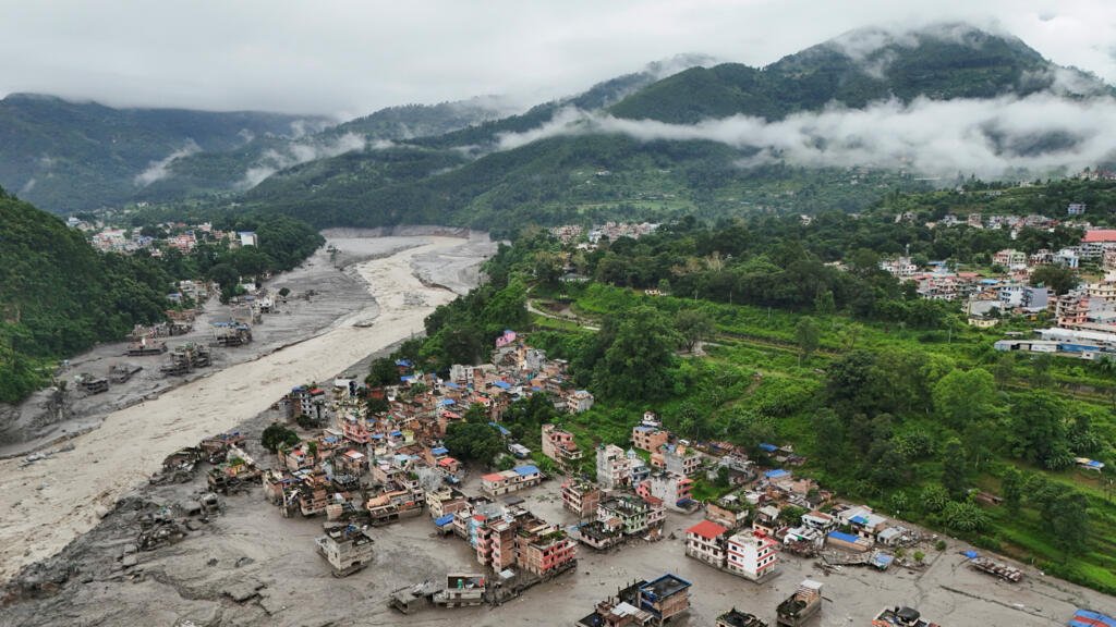
New Delhi: A devastating flash flood carrying water, ice, rocks and debris through Nepal’s Himalayan valleys on August 26 has exposed the vulnerability of communities and critical infrastructure in one of the world’s most fragile mountain regions. The disaster struck Nepal’s Rasuwa and Nuwakot districts and affected China’s Gyirong County and the Gyirong border crossing. Roads, bridges, homes, businesses and power infrastructure were damaged as the surge moved rapidly through narrow mountain valleys. Hundreds of people have been reported dead and thousands remain missing, while rescue operations continue amid difficult terrain, damaged roads and debris.
Glacier collapse, not dam failure
Initial reports suggested that an earthquake may have triggered the disaster. The assessment was later revised. The US Geological Survey (USGS) said the event was initially recorded as an earthquake but further analysis showed that the seismic energy was generated by a glacial collapse and debris flow, with no conventional earthquake occurring. USGS said the debris flow and flooding travelled nearly 100 km through the Trishuli and Bhote Koshi river systems, affecting populated areas and the Rasuwagadhi border region. Reuters, citing satellite imagery and experts, also reported that the disaster may have begun when part of a glacier broke away and crashed onto the valley floor, triggering an ice-and-rock avalanche and subsequent flooding. Importantly, there is currently no evidence that an existing hydropower dam triggered the August 26 disaster. The concern is instead about infrastructure vulnerability. Hydropower plants, transmission facilities, roads and bridges are located along narrow river valleys, leaving them exposed when large volumes of water and debris move downstream.
Chinese Hydropower and Infrastructure Concerns
The Trishuli and Bhote Koshi corridors have become important centres of hydropower development, including projects involving Chinese companies or financing. This has renewed questions about infrastructure planning in a region exposed to earthquakes, landslides, floods and glacier-related hazards. However, linking Chinese-built infrastructure directly to the cause of the flood would go beyond the available evidence. The larger concern is whether critical infrastructure has become concentrated in areas where a single extreme event can disrupt several interconnected systems. The disaster also affected workers at hydropower projects. Workers were reportedly stranded inside a tunnel at the Upper Trishuli-1 Hydropower Project, with rescue operations complicated by steep terrain and damaged access routes.
The consequences of the disaster extend beyond Nepal and China. The Trishuli River is a tributary of the Narayani-Gandak river system, which flows into India. This makes major Himalayan floods a potential downstream concern for northern India, particularly Bihar and Uttar Pradesh. The disaster has also directly affected Indian nationals. The Ministry of External Affairs said Indian nationals were among those rescued, while others remained untraceable in the affected areas, with communication disruptions complicating efforts to establish their whereabouts. India has also stepped up humanitarian assistance and coordination with Nepal. The developments underline the importance of timely information-sharing between Nepal, China and India on river levels, landslides, glacier-related events and emergency warnings. For India, the issue is not limited to the immediate rescue of its citizens. A major hazard originating in the high Himalayas can quickly affect downstream river systems and communities across the border.
Climate and infrastructure risks
The disaster has also renewed attention to changing conditions in the Himalayan cryosphere. Rising temperatures are contributing to glacier retreat and changes in snow and ice conditions, while scientists are examining whether these changes may have contributed to instability preceding the collapse. Climate change alone, however, cannot explain the disaster. Geological instability, steep terrain, weather, glacier conditions and human exposure can interact to produce extreme events. The incident also demonstrates why infrastructure safety cannot be assessed by looking only at individual dams. A power plant may survive while its access road is destroyed. A transmission station may be buried by debris, while a bridge may fail under the impact of rocks, mud and ice. The real concern is therefore network-level vulnerability: damage to one road, bridge, transmission line or power facility can disrupt an entire infrastructure corridor.
A warning for Himalayan infrastructure
The Trishuli disaster is more than a flood story. It is a warning about the risks of developing critical infrastructure in an increasingly uncertain mountain environment. Nepal needs hydropower and infrastructure for economic development. But future projects will require stronger multi-hazard assessments, better mapping of high-risk areas and infrastructure designed to withstand the combined effects of floods, landslides, earthquakes and glacier-related events. Early-warning systems will also need to integrate glacier, landslide, rainfall, river and seismic monitoring. The USGS has already highlighted the importance of satellite-based hazard mapping in supporting response and recovery following the disaster. For India, stronger coordination with Nepal is equally important because a disaster originating in the high Himalayas can quickly become a downstream emergency. The immediate priority remains rescue, relief and recovery. But once the crisis passes, the larger question will be whether Nepal, China and India can make Himalayan infrastructure and communities more resilient to a new generation of interconnected mountain hazards. The Trishuli disaster has shown that mountain hazards do not respect borders, and disaster preparedness cannot afford to either.